Sacramento continues to attract homebuyers looking for distinct architectural styles and strategic proximity to Northern California hubs. As of April 2026, the local housing market requires a precise understanding of hyper-local inventory rather than broad regional trends. Finding the right property means aligning your daily transit requirements with specific geographical boundaries.
Navigating the capital city involves evaluating everything from historic grid layouts to newer suburban developments. Buyers must weigh the benefits of walkable urban centers against areas offering larger lot sizes and immediate highway access. Understanding these distinct zones is the first step toward making a sound real estate investment this year.
Navigating the 2026 Sacramento Area Market
The current Sacramento real estate landscape presents a city-wide median home price ranging from roughly $500,000 to $550,000. These figures reflect a broad average across highly varied geographical zones, meaning localized pricing often diverges sharply from the city median. Buyers entering the market this spring need to focus on specific zip codes rather than relying on generalized data.
The physical layout of the city heavily dictates property values and daily logistics. Major transit corridors like I-5, I-80, and US-50 slice through the region, creating distinct boundaries between architectural eras and commercial hubs. The Sacramento River and American River also serve as natural borders that define property lines and recreational access.
Sacramento's 2026 market presents a highly localized environment where buyers must prioritize specific architectural styles and transit access over broad city-wide metrics. A home located directly on the central grid will carry a different price per square foot compared to a newer build in the northern subdivisions. Success in this environment requires targeting neighborhoods that match your exact logistical requirements.
The regional economy remains heavily anchored by government sectors and healthcare networks - a dynamic that stabilizes local property values. This employment stability creates a consistent baseline of housing demand regardless of seasonal fluctuations. Buyers must move decisively when well-priced inventory hits the market in these established zip codes.
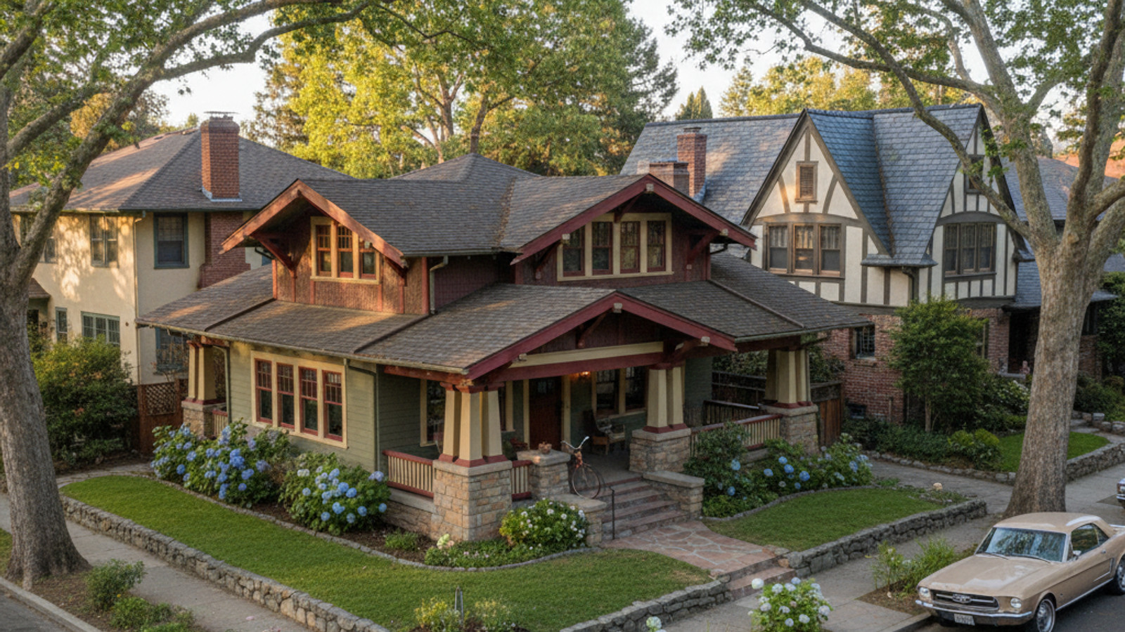
East Sacramento
Buyers targeting East Sacramento will encounter a premium market with a median home price hovering around $725,000. This pricing reflects the area's established streetscapes and standard urban lot sizes that rarely expand beyond a quarter acre. The limited inventory of available homes keeps competition strict among buyers looking for historic properties.
The dominant architectural styles in this zone are meticulously maintained Craftsman bungalows and classic Tudor revivals. Many of these properties feature original hardwood flooring and period-specific masonry that date back to the early twentieth century. The premium pricing in East Sacramento is directly tied to the strict preservation of its historic architectural integrity and immediate grid access.
Street parking is generally ample, though many historic properties feature detached single-car garages positioned at the rear of the lot. The mature sycamore trees provide massive shade canopies that drastically lower summer cooling costs. These natural features are highly protected by local city ordinances and neighborhood associations.
East Sacramento Commutes, Amenities, and Schools
Daily travel from East Sacramento is highly efficient, featuring a 15 to 20-minute commute to Downtown Sacramento. Drivers benefit from multiple immediate access points to US-50, while the surface streets provide alternative routes during peak travel hours. This central positioning drastically cuts down on vehicle time for those working in the primary commercial districts.
The neighborhood surrounds McKinley Park, a major green space known for its extensive rose garden and running paths. Residents also live in close proximity to the UC Davis Medical Center, a major regional employer and healthcare hub. Properties in this geographical area fall strictly within the Sacramento City Unified School District boundaries.
Land Park
Moving directly south of the central grid, Land Park commands a median home price of approximately $740,000. This price point secures larger average property sizes compared to other historic zones within the city limits. Buyers often target this area to gain additional square footage without sacrificing proximity to core commercial districts.
The housing stock is defined by vintage architecture, heavily featuring Spanish Revival estates and historic Tudor homes. Mature tree canopies line the winding streets, distinguishing the layout from the strict grid pattern found further north. Land Park's larger lot sizes provide unmatched privacy profiles for properties located this close to the city center.
Many buyers are drawn to the lack of strict Homeowner Association regulations in this specific zip code. This freedom allows property owners to execute custom renovations or add accessory dwelling units to their large parcels. The combination of architectural freedom and substantial lot dimensions makes this area a prime target for long-term holds.
Land Park Commutes, Amenities, and Schools
Residents navigating from Land Park expect a 15 to 20-minute drive to Downtown Sacramento. Commuters can choose between utilizing surface streets like Riverside Boulevard or jumping onto I-5 for a rapid transit option. The dual access points ensure consistent travel times regardless of highway congestion.
The area is anchored by William Land Park, a massive recreational space housing the Sacramento Zoo and a local golf course. These facilities draw visitors from across the region but remain immediate amenities for local property owners. Homes in this zip code map directly into the Sacramento City Unified School District boundaries.
Midtown
Midtown represents the high-density urban core of the city, featuring a median home price of roughly $649,000. Buyers here accept smaller lot sizes and frequent Homeowner Association dues in exchange for immediate access to commercial corridors. The real estate inventory is a sharp contrast of eras, blending historic Victorian homes with modern infill condo developments.
Parking is a premium commodity in this zone, and many properties rely on street parking permits rather than private garages. Despite the spatial constraints, Midtown offers the highest functionality for buyers prioritizing a walkable, car-independent lifestyle. The dense concentration of restaurants, grocery stores, and retail spaces exists mere steps from residential front doors.
The local market here moves rapidly, with properties often receiving offers within days of listing. Buyers must be prepared to navigate tight inspection timelines and competitive bidding environments for turnkey units. Securing a property in this zip code requires a streamlined financing strategy and immediate action.
Midtown Commutes, Amenities, and Schools
Commuting from Midtown is remarkably brief, typically requiring only a 5 to 10-minute trip to Downtown offices. The area boasts immediate access to multiple SacRT light rail stations, heavily reducing reliance on personal vehicles. Cyclists also utilize the dedicated bike lanes that connect directly to the American River Bike Trail.
The neighborhood's commercial grid provides dense, walkable access to daily necessities and entertainment venues. Geographically, Midtown falls under the jurisdiction of the Sacramento City Unified School District. Buyers targeting this area prioritize infrastructure and transit access over private outdoor space.
Natomas
Positioned just north of the central city, Natomas offers accessible market entry points with median home prices ranging from $480,000 to $525,000. The housing inventory heavily favors modern stucco architecture situated within planned subdivision layouts. Buyers typically find properties boasting 1,800 to 2,500 square feet on standard suburban lots.
This zone was developed much later than the city core, resulting in wider streets, attached multi-car garages, and modern HVAC systems. The newer construction standards often mean fewer immediate maintenance concerns for incoming buyers. Ultimately, Natomas delivers the highest square footage per dollar within a 20-minute radius of the city core.
The local infrastructure was designed to handle a high volume of daily commuters, featuring wide arterial roads and synchronized traffic signals. Retail centers and grocery chains are strategically placed at major intersections to minimize driving distances for daily errands. This intelligent urban planning creates a highly functional environment for residents balancing busy schedules.
Natomas Commutes, Amenities, and Schools
Drivers in Natomas generally face a 15 to 25-minute commute to Downtown via I-5 and I-80. The area is also positioned immediately adjacent to the Sacramento International Airport, streamlining travel for frequent flyers. Public transit options are currently expanding, with the SacRT Green Line to the Airport project pushing forward.
The highly anticipated Dos Rios station is expected to open in late 2026, which will further connect the northern subdivisions to the downtown grid. Properties located north of the American River here map to the Natomas Unified School District boundaries. The combination of highway access and expanding rail lines makes the logistics highly favorable for regional commuters.
Pocket-Greenhaven
The Pocket-Greenhaven area occupies a distinct geographical curve along the water, with median home prices sitting between $640,000 and $699,000. The layout is characterized by standard suburban lot configurations that accommodate sprawling, single-story properties. The architectural landscape is dominated by mid-century ranch-style homes and custom luxury riverfront estates.
Because the neighborhood is bordered by the river on three sides, there are limited entry and exit points for vehicles. The secluded river bend geography naturally eliminates pass-through traffic, stabilizing property values and reducing street noise. This unique physical boundary creates an isolated pocket of residential streets entirely separated from commercial thoroughfares.
The architectural uniformity of the area is maintained by established property lines and a lack of available dirt for new construction. Most transactions involve updated vintage properties rather than newly built structures. Buyers entering this specific market must budget for potential modernization of original mid-century plumbing and electrical systems.
Pocket-Greenhaven Commutes, Amenities, and Schools
Commuting out of the Pocket area typically involves a 20 to 30-minute drive to Downtown via I-5. The limited access points to the highway can create minor bottlenecks during morning travel hours, but the route is generally straightforward. Surface streets provide alternative travel paths, though they significantly increase overall transit times.
Residents enjoy immediate access to the Sacramento River Parkway Trail, providing miles of paved paths for cyclists and runners. The interior of the neighborhood also features Lake Greenhaven, offering private water access for adjacent property owners. This entire geographical sector falls within the Sacramento City Unified School District boundaries.
Frequently Asked Questions
Which Sacramento neighborhoods offer the lowest median home prices in 2026?
Natomas currently provides the lowest median home prices among the primary target areas, ranging from $480,000 to $525,000. This price point secures significantly more square footage than properties located on the central grid. Buyers looking to maximize their purchasing power within 20 minutes of the city center focus heavily on this northern sector.
How do commute times to Downtown Sacramento vary by neighborhood?
Midtown offers the fastest commute with a 5 to 10-minute transit time via light rail or surface streets. East Sacramento and Land Park require a 15 to 20-minute drive, while Natomas and Pocket-Greenhaven average 20 to 30 minutes depending on I-5 traffic. Transit times are heavily dictated by your proximity to the central highway corridors.
What are the geographical boundaries for the Natomas Unified School District?
The Natomas Unified School District boundaries generally encompass the residential areas located north of the American River and west of the Steelhead Creek. This includes both the North Natomas and South Natomas subdivisions stretching up toward the Sacramento International Airport. Buyers must verify specific property addresses against the 2026 district maps to confirm exact routing.
Check out this article next